The Belgian observatory covers two peri-urban locations in West Flanders: Abeele in Zwevegem and Marke in Kortrijk. Both neighbourhoods combine housing, open space, water systems and strategic green connections. Their biodiversity is affected by habitat fragmentation, soil sealing and climate change.
Prolonged drought reduces water availability and puts urban ecosystems under pressure.
Paved surfaces intensify heat stress, increasing the need for tree canopy, shade and evapotranspiration.
Heavy precipitation creates flood risk where sealed surfaces prevent infiltration and accelerate runoff.
Abeele
Abeele is a district-scale test area for implementing the Zwevegem Biodiversity Charter and multi-year policy plan. Priorities include forest expansion, native species, old trees, hedgerows, wooded edges, food forests and nature-friendly management in streets, agricultural areas, neighbourhood green space and school environments.
Marke
Marke translates the Kortrijk Biodiversity Action Plan and Trees Master Plan into neighbourhood action. Its central spatial ambition is to strengthen the ecological connection between OC Marke and Preshoekbos, while protecting valuable inner open spaces and increasing tree cover, low greenery, infiltration and water buffering.
Soil sealing provides a baseline for depaving and infiltration measures.
Geopunt and municipal layers for soil sealing, land cover, biological value, flood-prone areas, trees and mowing management.
Remote sensing
Open satellite data, including Sentinel-2, can monitor vegetation condition and drought stress.
Field surveys
Site observations, habitat inventories and student spatial analysis.
Ecological indicators
Tree and forest area, canopy cover, hedgerow length, ecologically managed grassland, pollinators and selected local species.
Citizen science
Species observations through platforms such as iNaturalist and Observation.org.
Co-creation
Student studios, workshops and stakeholder feedback connect evidence with local design proposals.
Ground-cover map for Marke.
Ground-cover map for Abeele.
Stakeholder workshop
On 13 May, from 10:00 to 12:00, first-year Built Environment students at Howest University College presented the outcomes of Project Buurt to external stakeholders. Four teams of four to five students had developed future visions for social housing neighbourhoods in Zwevegem and Marke. Their work addressed quality of life, sustainability, community interaction and public-space improvement. Using physical models and PowerPoint presentations, they pitched to municipal representatives and housing association Elan. The discussion gave students professional presentation experience and allowed stakeholders to test the relevance of the proposals for future neighbourhood development.
Reconnect isolated habitats to larger green and blue-green networks, notably the Guldensporenpad in Abeele and the OC Marke–Preshoekbos corridor in Marke.
Less soil sealing
Narrow oversized roads, depave hard surfaces and use permeable construction to reduce runoff and heat.
Water resilience
Increase infiltration, rainwater reuse and buffering, and upgrade the ecological function of the Markebeek.
Habitat diversity
Provide native trees, shrubs, flowers, green roofs and façades, dead wood, nesting features and fauna passages.
Long-term management
Use low-maintenance vegetation, ecological mowing and agreements with municipalities, residents and nature organisations.
Participation
Involve residents, schools, farmers, students and neighbourhood organisations in monitoring, design and stewardship.
The four cases were produced in the first-year Howest Built Environment course Project Buurt. Each team analysed subsoil, networks, occupation and orgware, developed a SWOT synthesis, studied reference projects and translated the analysis into a future vision. The project pages below use the full text and original figures from the Word submissions.
Abeele
Students
Delia Franssen, Thor Joos, Juna Govaert, Cyriel Wydooghe and Ruben Verbeke
Programme
Howest Built Environment, first year, Project Buurt
Location
Abeele, Zwevegem
Date
17 June 2026
Project overview
The Abeele study covers 133 housing units, including bungalows and three three-storey apartment buildings. The biodiversity focus identifies pollinators, birds, butterflies, observed vegetation and ecosystem services such as pollination, natural control and climate adaptation.
Biodiversity and design actions
Ecological garden beside the cycling route with wildflowers, an insect hotel and dead wood.
Natural playground with wildflowers, water buffering and a play forest.
Food forest providing habitat for multiple species.
Reuse of the Transfo industrial site for bats and swallows.
Ecological corridor along the Guldensporenpad.
Reduce paving, connect habitats, improve rainwater use and agree shared maintenance rules.
Masterplan linking ecological improvements with neighbourhood design.
Ecological networks, climate risks and ongoing spatial projects.
Abeli
Students
Cyanne Neyt, Tristan Vinckier, Maarten Decat, Thurian Van de Woestyne and Jonah Cappelle
Programme
Howest Built Environment, first year, Project Buurt
Location
Abeele, Zwevegem
Date
17 June 2026
Project overview
The team studied the same 133-unit social housing neighbourhood and focused its future vision on biodiversity and blue-green networks. The fauna analysis and spatial mapping connect species observations with the surrounding landscape.
Biodiversity and design actions
Narrow roads to create green zones with native mosses, grasses, shrubs and trees.
Connect neighbourhood greenery to the Guldensporenpad blue-green network.
Increase rainwater infiltration.
Provide bat boxes, insect hotels, green façades and wildlife tunnels.
Use low-maintenance vegetation and agreements with Natuurpunt and the municipality of Zwevegem.
Integrated neighbourhood plan with water, greenery and reference examples.
Examples of fauna-supporting infrastructure and green façades.
Vision for the Marke Neighbourhood
Students
Jin-Joo De Roeck, Marthe Ricourt, Ruben Calis and Lena De Becker
Programme
Howest Built Environment, first year, Project Buurt
Location
Ter Doenaert, Marke
Date
17 June 2026
Project overview
The Marke case covers 101 houses along the Markebeek. The team recorded deciduous trees, shrubs, flowers, insects and birds and used this inventory to formulate an animal-friendly neighbourhood concept.
Biodiversity and design actions
Apply the 8V model: food, moisture, safety, reproduction, connection, distribution, variation and avoiding disruption.
Ecologically upgrade the Markebeek.
Create a greater variation of habitats.
Plant species selected to strengthen biodiversity.
Develop community-supported agriculture, collective gardens and recycling gardens.
Animal-friendly neighbourhood plan with habitat interventions.
Markebeek upgrade and habitat concept.
Project Buurt Ter Doenaert
Students
Foeke Cattry, James Jungbluth, Milo Nuytinck and Mauro Van Cauwenberge
Programme
Howest Built Environment, first year, Project Buurt
Location
Ter Doenaert, Marke
Date
17 June 2026
Project overview
This project also addresses the 101-house neighbourhood along the Markebeek and translates its biodiversity and blue-green analysis into a compact set of spatial interventions.
Biodiversity and design actions
Create a large green corridor to stimulate local biodiversity.
Install extensive green roofs.
Reconstruct roads using water-permeable paving.
Create a shared vegetable garden.
Use green façades on residential blocks for climate regulation.
Concept plan for the Ter Doenaert neighbourhood.
Reference images for green roofs, water buffering and green façades.
Governance and Expected Outputs
The observatory uses a multi-stakeholder model. Zwevegem leads the Abeele work through its biodiversity charter and multi-year plan, supported by the Green and Flower Advisory Council, Natuurpunt and local organisations. Kortrijk leads the Marke work through its environment and green services, Biodiversity Action Plan and Trees Master Plan, with ecological input from Natuurpunt Kortrijk and local partners. Residents, schools, farmers, neighbourhood committees and students contribute as observers, co-designers and co-managers.
Expected outputs
Urban Biodiversity Report.
Interactive GIS maps and an Urban Nature Atlas.
Catalogue of Good Practices, including student designs.
Data-informed policy briefs and accessible neighbourhood reports.
Expected benefits
Evidence-based planning and investment.
Greater resilience to drought, heat and flooding.
Stronger ecological connectivity.
Greater community involvement, awareness and neighbourhood well-being.
Project U.BI.TEACH – URBAN BIODIVERSITY TEACHING AND LEARNING IN HIGHER EDUCATION SECTOR (2023-1-ES01-KA220-HED-000154248 )
Funded by the European Union. Views and opinions expressed are however those of the author(s) only and do not necessarily reflect those of the European Union or the European Education and Culture Executive Agency (EACEA). Neither the European Union nor EACEA can be held responsible for them.
This work is licensed under CC BY-NC 4.0. To view a copy of this license, visit here.
Privacy Policy
By understanding that the use of your data requires your confidence, we follow the current regulations and the appropriate procedures in the treatment and data protection. Find more here.

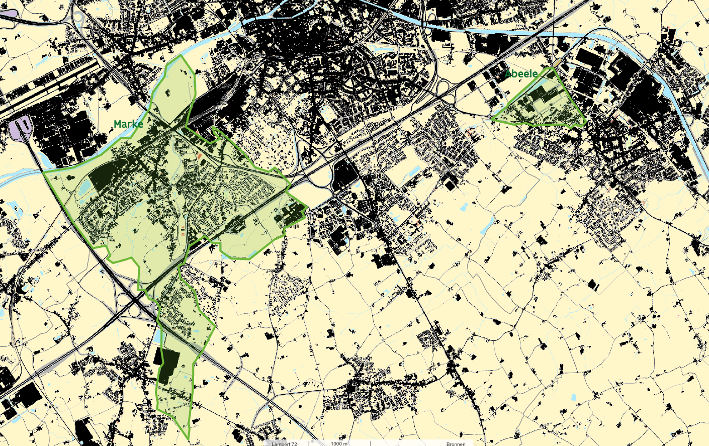 Soil sealing provides a baseline for depaving and infiltration measures.
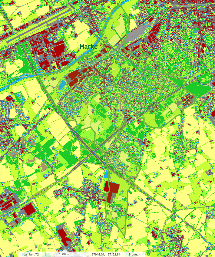 Ground-cover map for Marke.
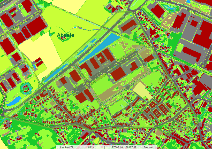 Ground-cover map for Abeele.
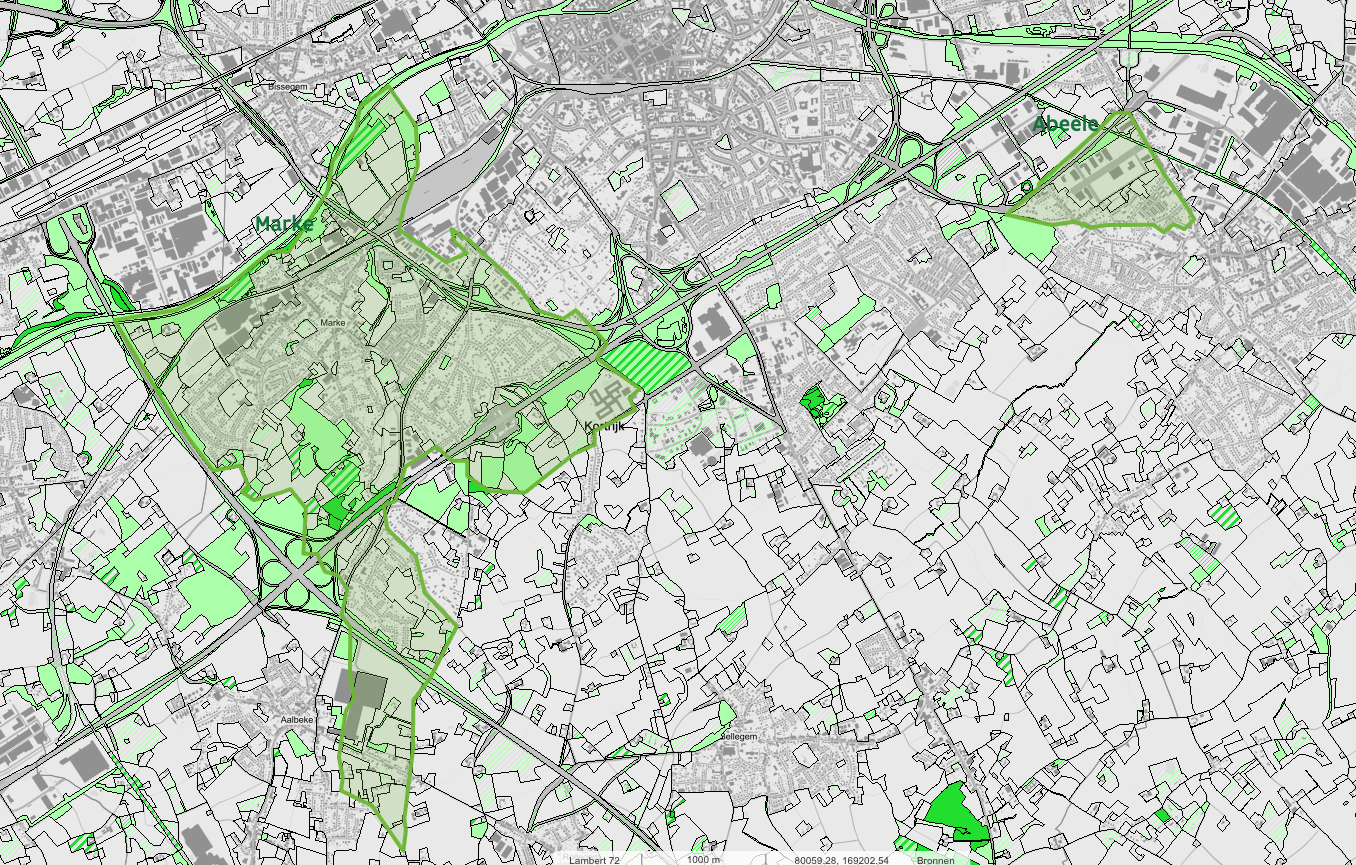 Biological valuation mapping supports habitat prioritisation.
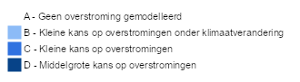 The Kortrijk Bee Plan supports pollinator-friendly action.
 Masterplan linking ecological improvements with neighbourhood design.
 Ecological networks, climate risks and ongoing spatial projects.
 Integrated neighbourhood plan with water, greenery and reference examples.
 Examples of fauna-supporting infrastructure and green façades.
 Animal-friendly neighbourhood plan with habitat interventions.
 Markebeek upgrade and habitat concept.
 Concept plan for the Ter Doenaert neighbourhood.
 Reference images for green roofs, water buffering and green façades.

